All categories
caret-down
cartcart

West Highland Way Map Booklet: 1:25,000 OS Route Mapping (British Long Distance Trails)

 
From unknown
Only 1 items left in stock
West Highland Way Map Booklet: 1:25,000 OS Route Mapping (British Long Distance Trails)

Description

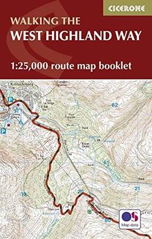
Map of the 153km (90 mile) West Highland Way between Milgnavie and Fort William. Suitable for walkers with some experience at walking longer distances this Scottish Long Distance Route can be walked in 1 week.


  • The full route is shown on 1:25,000 OS maps
  • Route via Loch Lomond, Rannoch Moor, Glencoe, Drymen, Crianlarich, Tyndrum, Kinlochleven
  • The map booklet can be used to walk the path in either direction
  • It is conveniently sized for slipping into a jacket pocket or top of a rucksack
  • An accompanying Cicerone guidebook - West Highland Way is also available, which includes a copy of this map booklet

Product details

EAN/ISBN:
9781852848989
Medium:
Paperback
Number of pages:
56
Publication date:
2016-08-15
Publisher:
Cicerone Press
EAN/ISBN:
9781852848989
Medium:
Paperback
Number of pages:
56
Publication date:
2016-08-15
Publisher:
Cicerone Press

Shipping

laposte
The edition supplied may vary.
Condition
Condition
Learn more
€10.75
available immediately
New €13.00 You save €2.25 (17%)
€10.75
incl. VAT, plus  Shipping costs
paypalvisamastercardamexcartebleue
  • Icon badgeChecked second-hand items
  • Icon packageFree shipping from €19
  • Icon vanWith you in 2-4 working days